In the Glass Beach, a beach in MacKerricher State Park near Fort Bragg, California, like the name tells you, you’d normally find too many glass pieces on the beach. These glass pieces that people often find in beaches like these, aren’t exactly those sharp shards of glass that are sharp enough to harm you. Rather they are physically and chemically weathered pieces of glass – round and small.
This type of glass is called sea glass and has been a fancy of those hobbyists who like collecting these pieces to make beautiful adornments.
This kind of glass, often found on some beaches usually starts as shards of broken glass from dump or other such sources. In about a span of 1-2 years, the tumbling and weathering makes these pieces smooth and rounded. And then they are collectively known as “genuine sea glass”
At this particular beach in California, the beach glass that has formed over the years, first started coming in when residents who lived close to the beach started dumping garbage into the beach. Local clean up services tried to clean up the mess, but most of it had already gone in for natural weathering by that time.
Soon after the clean-up services came around, the beach became a great place for hobbyists to collect these naturally weathered beautiful glass pieces. All the trash that was first thought to be a mess, now became a tourist attraction – Naturally weathered genuine sea glass was a thing of natural beauty now. And then this smuggling of sea glass by tourists had to stop. First the mess had to stop, now the mess being taken away by tourists had to stop.
And once the glass has started to go away, now there is a move to replace all the glass – that was once considered garbage!
Tectonic plates float at a certain elevation on Earth. This elevation is decided by what lies on the plate. So, depending on the density and thickness of the matter that is present on a tectonic plate, the plate adjusts its elevation to maintain a gravitational equilibrium between the uppermost solid mantle and the mechanically weak layer – Asthenosphere – which lies just below it. This is call Isostasy.
During the Ice age when the land masses were covered in ice sheets up to 3 kilometres thick, the landmasses got depressed. This was about 20,000 years ago (last part of the last ice age) when the massive ice weight made the mechanically weak mantle below the solid mantle, deform. Under pressure, the semi-solid-ish mantle below, started flowing to other places where the solid mantle was higher and allowed a greater place for the ductiley flowing mantle below the plates.
When this period ended, the glaciers started retreating and the landmasses started rising from depression. Now, since the mantle below is not totally liquid, it took a lot of time for it to rush back into place from where it was displaced by the primitive heavy ice covered land. In fact, at some places on Earth, this rebound is still happening – This is known as the post glacial rebound.
This can be seen in some parts of Finland, where the land around the Gulf of Bothnia rises about 1 cm each year to maintain the gravitational equilibrium between the Lithosphere (solid mass) and the Asthenosphere (the semi-solid-ish stuff below the solid mass)! As a result the land which was previously below sea, rises upwards and Finland expands in area – about 7 Square kilometres annually. This rise has been recorded by the BIFROST GPS network. And is estimated to continue for the next 10,000 years, not necessarily at the same rate.
Of course there are taller mountains than the Everest. Like if you consider the whole solar system, the tallest mountain is in Mars. It is about 2.5 times the height of Mt. Everest, and had it been on Earth, going to its peak would have required you to wear a space suit. It is about 21 km tall!
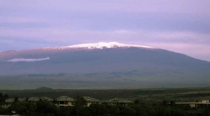
But here on earth, you’d think Mt. Everest is the tallest mountain. No, it is not. In fact, the peak of Mt. Everest is of course the Highest peak. So, it is the “Highest” mountain, not the “tallest”. The tallest one would be the Mauna Kea in Hawaii. Subtle differences, you see…
Tallest means – Measuring the mountain from its base to the peak. (Which seems pretty fair to me, but it isn’t the norm). Highest means – Measuring the mountain from the sea level to the peak.
Measuring Heights
Mountain peaks are measured from the sea level. Suppose a mountain is in the sea, the part of it which lies below the sea isn’t added to it’s height. So a mountain lying in the sea says, “unfair!”
Measuring sea level in turn is another complex problem because the sea isn’t at the same level everywhere. In fact, the sea level is much higher at the base of a mountain because the mountain’s mass increases the gravity and pulls the sea water making it higher there. Even if there isn’t any sea around mount Everest, the calculated sea level (higher than normal) is used as the base of the mountain. From this raised sea level to the peak, Mt. Everest measures 8,848 m.
This is how sea level is calculated:
Therefore, Mt. Everest is 8,848 meters tall, because there is no part of it which is under the sea (because there is no sea there). Also, Mt. Everest is 8,848 meters high because its peak is 8,848 meters from the calculated sea level.
Mauna Kea
Mauna Kea, a dormant volcano in Hawaii, is not popularly known because it’s peak is just 4207 m above the sea level. So, it is 4,207 meters high. Mt. Everest is much higher!
But the important thing to note is that a huge part of the volcano is under the sea level. In other words, its base is on the ocean bed, not on land. So, if measured from the base, it is 10,100 meters tall! That is more than 1.2 kilometres taller than the mount Everest.
That means, if there were no sea, Mauna Kea would have been a clear winner. Think of it this way – Suppose you cut both the mountain at their bases and place them on a huge flat land, Kea would be 1.2 kilometers higher! Given it is not a constant, I wonder why “sea level” is used as a standard to measure heights of mountains.
Clearly, Kea should be known better. School text books should at least have a mention of it.
Another Twist
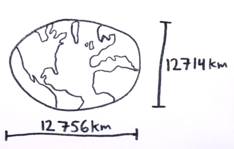
Now if you think that is all I have to say about the highest and tallest things, you are wrong. There are all sorts of complex measurements we can do. What if, you start measuring the height of a mountain from the centre of the earth?
I don’t think that would be fair given the odd shape of earth – It is about 42 km farther across the equator than it is at the poles. That is too much distance to ignore. Had earth been a perfect sphere, this measurement would have made sense.
earth measured at poles and equator
Nevertheless, let’s imagine that we have started measuring the height of a mountain peak by measuring its distance from the centre of the earth. In that case, Mt. Chimborazo, an ice-capped inactive volcano and the highest mountain in Ecuador, would have been the highest one. Even with a peak which is at an elevation of 6,268 meters from the sea level, it is still the most distant place from the centre of the earth. The peak of it is 6,384 km from the centre, while that of Mt. Everest is 6,382 km from the centre of the earth. In some way, even Chimborazo is taller than Mt. Everest. Still, we’re never taught about it in schools!
If there are any science teachers reading this, please tell these things to the kids. I’ll be honoured!
Did you like this article?
Every day I send out a newsletter with an un-cut new article and exclusive content for readers. It’s basically my way of keeping in touch with you and letting you know what’s going on. Your information is protected and I never spam.
Subscribe from the sidebar to stay connected. Feel free to reply to these newsletters too…
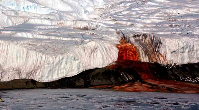
Red colored water, which gives it name blood falls, emerges continually from the edge of a glacier in east Antarctica. The source of this red-colored-water is said to be a lake that is buried 400 meters under a glacier. The water of this lake is extremely salty and is about 3 times saltier than sea water. It is so salty that even at temperatures that Antarctica experiences, it doesn’t freeze. The lake is estimated to be around 5 million years old!
5 million years ago, this part of Antarctica was under sea water. Gradually glaciers started collecting around and over the lake. This made the water body isolated from the main sea and it became a lake eventually. Over time, as it got separated – like the Taal lake – it grew saltier (Taal lake got isolated too, but it turned less saltier). With this lake, the organisms living in it got trapped in this natural time capsule too.
What gives it the color red?
The falls are not red due to some mysterious spores that were found in the red rains of Kerala. What gives it that color, is a popular chemical phenomenon – iron rust.
The lake gets its supply of iron from the bedrock below it. As the water leaks out from the edge, the iron present in water gets oxidized. This oxidized or rusted iron gives the water its red color.
And since the lake has almost no supply of oxygen from around it, the water underneath is probably still like…water – not red (I’m not sure about it).
But that isn’t even anything interesting I’ve talked about the blood falls yet. The most incredible thing is the creatures that have been found living in those waters.
For millions of years, in the extremely salty waters of the lake with almost no oxygen or sun light, scientists have found a kind of micro-organism that has survived there. The kind of process they use to live has dazed scientists.
The microbes living there have been surviving on iron and sulfur! By breaking sulfates to get oxygen. And iron has been restoring the sulfates. It is a beautiful cycle that has never been seen anywhere else. This strange cycle has widened our view on how life could exist on other planets without oxygen in native state.
First, think of something that is 1,200 km in length, 3000 m in height and yet it is complete buried under the Antarctic ice. A whole mountain range called the Gamburtsev Mountain Range in Antarctica has remained unexplored, buried for centuries under a 2 to 4 kilometer thick sheet of ice. The range is named after Grigoriy A. Gamburtsev – a Russian geophysicist.
It amazes me how something of the size of European Alps, right here on earth, has remained unexplored for decades. Scientists estimate that these mountains are several millions of years old. But, till date they have no concrete idea on how they were actually formed.
In the words of Robin Bell, a geophysicist at Columbia University:
Amazingly, we have samples of the moon but none of the Gamburtsevs’.
Discovery: year 1958
In the year 1958, these mountains were discovered by a Soviet expedition. For exploration, this expedition investigated the surface using seismic sounding at around 10 points. During this time, not much detail was known.
Year 2000: It was only in the year 2000 that a project by British Antarctic Survey was able to produce a fairly detailed 3D map of Antarctica to date. As a result, some more information about these mountains was gathered. Still, it wasn’t enough for finding out their origins.
To solve the mystery of their origins, in the year 2011, aircrafts equipped with radars, lasers and various other meters were sent out by researchers to image the last unexplored mountain range on earth. They flew a distance of around 3 times the earth’s circumference over Antarctica – about 120,000 kilometers.
In the end, this flying around returned good results.
This Image gives you a rough idea about how deep these mountains are buried. [PDF]
I hope that in the coming years, scientists will be able to drill through the ice that has accumulated there for millions of years. And then, probably they’ll be able to retrieve real Gamburtsev rock samples for detailed investigation.
Note: Pardon me if I’ve been writing too much in the “Earth” category for the past few days. Trust me it is just a coincidence. In my defense, It is completely possible that a truly random die roll can land 6 consecutive 6s.
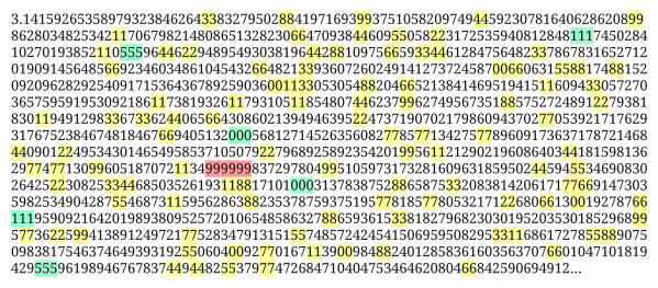
The Feynman point is one such example. It is a sequence of 6 nines somewhere in the decimal digits of pi. In short, you cursing me for writing under the same category for the past few days is not justified, logically.
Geologically this is quite a phenomenon and might get a bit confusing to grasp if you stop paying enough attention. Here we go…
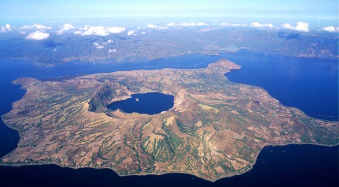
Island in a lake on an island in a lake…
Taal lake is a freshwater lake on the Luzon island of Philippines. Almost at the center of this lake, is an island called the volcano island. At the center of this island is another lake called the main crater lake. And in this lake is a small landmass called the Vulcan point. [map]
Now take a deep breath…in short, it is, Luzon island > Taal lake > Volcano island > Main crater lake > Vulcan Point.
The main crater lake: Even though the crater lake isn’t a very big lake, it is still claimed as the world’s largest lake on an island (Volcano Island) in a lake (Taal Lake) on an island (Luzon). Of course it is, where else in the whole world would you find a lake on an island in a lake on an island?
Vulcan point: On this world’s largest lake on an island in a lake on an island, is a tiny land mass called the Vulcan Point which is the world’s largest volcano in a lake (Main Crater Lake) on a volcano (Taal Volcano). It isn’t even big enough to support a small house.
Home to Unique Species
But all that is just a part of what is interesting about the Taal lake. Ecologically it is another marvel in a way that it is home to a few species of animals that are found nowhere else on earth. In this lake you’ll find the only varieties of fresh water sardines, sharks and sea snakes.
Reason: This lake was not a lake several thousands of years back. Then, due to volcanic eruptions, it got separated from the sea. Now the only thing that connected this water mass and the sea was Pansipit river. Gradually, several hundreds of years of precipitation converted this lake from a saltwater lake to a freshwater lake. For centuries, animals living here have remained isolated and have evolved into unique species to adapt to this desalination.
You should know: Meteor vs. Meteoroid vs. Meteorite
Meteor: The streak of light that we see in the sky is “Meteor”. When debris enters earth and gets burned up while entering, it leaves a streak of light. Unlike what is popularly believed, meteor is not the debris itself rather the word “meteor” refers to only the flash of light.
Meteoroid: A meteoroid is a mass that is small – ranging from a kilometer to only a few millimeters in diameter. Most meteoroids that enter the Earth’s atmosphere are so small that they vaporize completely and never reach the planet’s surface.
Meteorite: If the Meteoroid survives and reaches the earth’s surface, it becomes a Meteorite.
Hoba the Meteorite
About 80,000 years back, a ridiculously huge mix of Iron and Nickel entered the earth. It was so large that what was left out of all the burning through the atmosphere, measured 66,000 kg in the end. About half ton of this meteorite has gone to laboratories for research. Even after accounting for losses towards laboratories and vandalism, it is still the largest single mass of natural Iron on the Earth’s surface. It is the largest meteorite ever discovered till date and is called “Hoba”.
This meteorite was discovered by a farmer in Namibia in the year 1920. Since then, due to its mass, it has never been moved. The meteorite and the site has been declared as a national monument by the Namibian government and several tourists visit it every year.
Farmer’s Story:
One winter as I was hunting at the farm Hoba I noticed a strange rock. I sat down on it. Only its upper part was visible. The rock was black, and all around it was calcareous soil. I scratched the rock with my knife and saw there was a shine beneath the surface. I then chiselled off a piece and took it to the SWA Maatskappy in Grootfontein, whose director established it to be a meteorite.
If that was hardly interesting…
The most puzzling thing about this meteorite is probably not that it belongs to a very rare class of meteorites (Ataxite), but the fact that it has no crater to be seen around it. Normally, a meteorite of this size should have left a crater hundreds of meters wide.
The best theory that explains the absence of any preserved crater around it is that, this piece of rock must have hit the earth’s surface at a very low angle. As a result, it must have skipped on the surface like a flat stone on water surface. And in the end, must have landed at the place where it lies today.